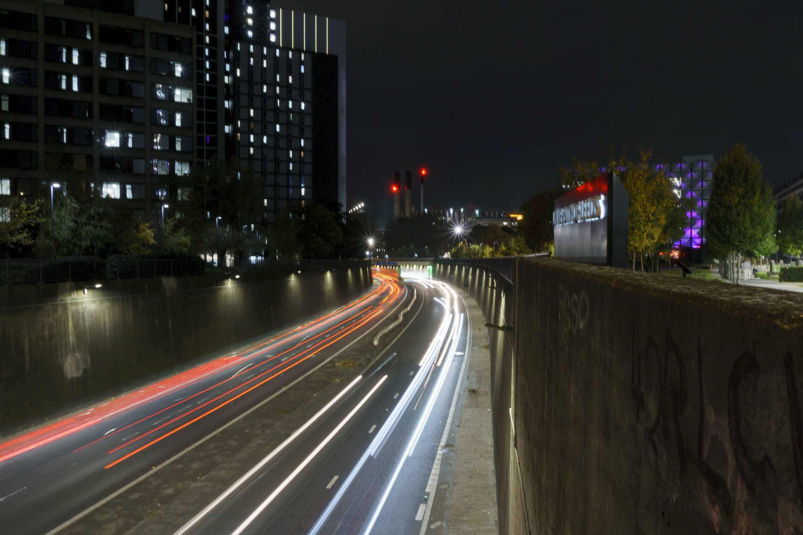
10 Best Places for Light Trail Photography in Leeds, Yorkshire
If you’re looking for the best places for light trail photography in Leeds, you don’t have to travel far. Leeds has a fantastic mixture of busy roads, bridges, modern architecture, historic buildings, canals and waterfronts that can all be turned into striking long-exposure photographs after dark.
Light trails are one of my favourite types of night photography because they can transform ordinary traffic into flowing lines of colour. With the right composition, the headlights and tail lights become leading lines that guide the viewer through the photograph.
1. Leeds Inner Ring Road – A58(M)
⭐ Best for: Dramatic traffic trails
📍 Google Maps – Leeds Inner Ring Road
If you’re specifically looking for light trail photography in Leeds, the A58(M) Leeds Inner Ring Road should be near the top of your list.
The road cuts through the city centre in sections of trench and tunnel, creating strong lines and interesting perspectives.
There are several pedestrian viewpoints and footbridges around the route, giving photographers opportunities to photograph the traffic from a safe elevated position.
📷 Composition idea
Look for a position where the road curves through the frame.
Rather than photographing the cars themselves, allow the traffic to create sweeping red and white lines.
Try positioning the road so it starts in one corner and leads towards the city.
Suggested starting settings:
- ISO 100
- f/8–f/11
- 10–20 seconds
- Manual focus
- RAW
- Tripod
Safety: Photograph from a legal pedestrian viewpoint or footbridge. Never enter the A58(M) carriageway.
2. Clarendon Road Footbridge
⭐ Best for: Elevated light trails
📍 Google Maps – Clarendon Road Footbridge, Leeds
The Clarendon Road footbridge provides a particularly interesting viewpoint over the Leeds Inner Ring Road.
A documented photograph from the bridge shows the A58(M) from above, demonstrating how the elevated viewpoint can reveal the shape of the road.
📷 Try this
Use a wide-angle lens and include some of the surrounding city rather than filling the entire frame with the road.
Try both landscape and portrait orientation.
A portrait composition can work particularly well when the traffic trails act as leading lines.
3. Great George Street / Woodhouse Square
⭐ Best for: City-centre traffic trails
📍 Google Maps – Great George Street, Leeds
The Great George Street and Woodhouse Square area provides another opportunity to photograph the Inner Ring Road from nearby pedestrian areas.
The elevated viewpoints around this part of Leeds can produce interesting compositions where traffic trails become leading lines through the city.
📷 Composition idea
Try positioning the camera so the traffic enters from the bottom of the frame.
Wait for several vehicles to pass before closing the shutter.
You may find that one exposure produces a much better pattern of red and white trails than another.
4. Armley Gyratory
⭐ Best for: Multiple streams of traffic
📍 Google Maps – Armley Gyratory, Leeds
Armley Gyratory is an excellent place to experiment with more complicated traffic patterns.
Instead of having one road travelling through your photograph, the surrounding roads can produce trails moving in different directions.
This can give you a much more dynamic photograph.
📷 Look for
- Curving traffic
- Red tail lights
- White headlights
- Traffic entering and leaving the junction
- Streetlights
- Bridges
- Reflections after rain
Don’t simply point your camera at the busiest part of the junction.
Explore the surrounding public areas and look for a viewpoint where the different roads create a strong geometric pattern.
Safety: Use designated pedestrian areas and crossings. Never photograph from the carriageway or road itself.
5. M621 – Safe Footbridge Viewpoints
⭐ Best for: Long, continuous motorway trails
The M621 provides another opportunity for photographing large volumes of moving traffic around Leeds.
The important thing here is where you photograph from.
Do not attempt to photograph from the motorway or its carriageways.
Instead, look for public footbridges and other legal viewpoints from which the motorway can be photographed safely.
📷 Try a telephoto lens
Most people automatically reach for a wide-angle lens for light trails.
Try something different.
A telephoto lens can compress the traffic and make multiple vehicles appear closer together.
For example, a 100–200mm equivalent can produce a completely different result from a wide-angle lens.
6. Wellington Place
⭐ Best for: Modern architecture and traffic
📍 Google Maps – Wellington Place, Leeds
Wellington Place gives you an opportunity to combine Leeds architecture with light trails.
Rather than making the traffic the entire subject, use moving vehicles as foreground interest while the illuminated buildings provide the main background.
Wellington Place is in the heart of Leeds and has access from Wellington Street, Whitehall Road and Northern Street.
📷 Best time to visit
Try arriving around 20–30 minutes after sunset.
This is often called blue hour.
You can still retain some colour in the sky while the artificial lights of Leeds begin to dominate the scene.
7. Leeds Dock
⭐ Best for: Reflections and night photography
Leeds Dock is one of my favourite alternatives to traditional traffic-trail locations.
Here, the aim isn’t necessarily to photograph huge streams of vehicles.
Instead, combine city lights, water, reflections and movement.
Leeds Dock is located around The Boulevard in LS10 1PZ and provides a mixture of waterfront, modern buildings and urban surroundings.
📷 Look for reflections
After rain, check the pavement and waterfront carefully.
Wet surfaces can produce reflections from:
- Street lights
- Building lights
- Vehicle headlights
- Signs
- Bridges
These reflections can add another layer to your long-exposure photographs.
8. Granary Wharf & the Dark Arches
⭐ Best for: Architecture, reflections and long exposures
📍 Google Maps – Granary Wharf, Leeds
Granary Wharf is one of the most interesting photography locations in central Leeds.
It combines the railway station, canal, River Aire, bridges, brick arches and modern development.
Granary Wharf is just a short walk from Leeds city centre and features cobbled bridges and working locks.
📷 Try more than traffic
This is a great location to experiment with:
15–30 second exposures
rather than only photographing vehicle trails.
Moving water, pedestrians and lights can all create interesting effects.
The railway architecture also provides strong framing opportunities.
9. Leeds Bridge & The Calls
⭐ Best for: Historic Leeds and urban night photography
For something different, head towards Leeds Bridge and The Calls.
This area allows you to combine vehicle movement with some of Leeds’ historic architecture.
Instead of trying to create huge motorway-style light trails, think about creating an image that shows Leeds at night.
Include:
- Leeds Bridge
- The River Aire
- Historic buildings
- Street lighting
- Passing vehicles
- Reflections
📷 Try a shorter exposure
You don’t always need a 20-second exposure.
Try:
1–5 seconds
and see how much movement you can capture while retaining detail in the architecture.
10. Hunslet Road & Leeds Waterfront
⭐ Best for: Urban traffic and reflections
📍 Google Maps – Hunslet Road, Leeds
The roads around the southern side of Leeds city centre provide another opportunity to combine traffic with the waterfront environment.
Look around the Hunslet Road, Crown Point Road and waterfront areas for compositions where traffic can be combined with Leeds’ buildings and bridges.
Rather than choosing one exact camera position, explore the surrounding public pavements and pedestrian areas.
📷 Look for leading lines
The best light-trail photographs often have somewhere for the viewer’s eye to travel.
Try to create a composition where:
traffic → bridge → buildings → skyline
forms a natural visual route through the photograph.
📍 Leeds Light Trail Locations – Quick Map Guide
| # | Location | Google Maps |
|---|---|---|
| 1 | Leeds Inner Ring Road – A58(M) | Open in Google Maps |
| 2 | Clarendon Road Footbridge | Open in Google Maps |
| 3 | Great George Street / Woodhouse Square | Open in Google Maps |
| 4 | Armley Gyratory | Open in Google Maps |
| 5 | M621 viewpoints | Open in Google Maps |
| 6 | Wellington Place | Open in Google Maps |
| 7 | Leeds Dock | Open in Google Maps |
| 8 | Granary Wharf & Dark Arches | Open in Google Maps |
| 9 | Leeds Bridge & The Calls | Open in Google Maps |
| 10 | Hunslet Road & Waterfront | Open in Google Maps |
📷 A Quick Tip Before You Go
Google Maps is useful for finding the general location, but don’t assume that the point shown is the best or safest place to set up your tripod.
Before photographing, check:
- Pedestrian access
- Footpaths
- Bridges
- Road closures
- Construction work
- Private land
- Lighting conditions
- Your position relative to traffic
Your safety should always come before getting the perfect photograph.
No responses yet